Update: 14/08/2026

The pressures on our 190km of strategic waterways caused by the drought conditions and the additional requirements for water to help tackle the major fire incident at Holme Fen are unprecedented and severe. We are very close to a critical tipping point in terms of the water levels in our system.

There has been no demonstrable abstraction from our system for farming irrigation since 27th July 2026 and evaporation caused by the hot weather is also having an impact.

This is a rapidly evolving situation with no significant rainfall on the horizon to help recover water levels.

  • We have been involved in multi-agency meetings.
  • We have allowed Homewood & District IDB to take water from our system and supported them with additional pumping equipment to enable this. Holme Fen is within Holmewood & District IDB’s area, and their watercourse networks run to and through Holme Fen.
  • Local farmers and operatives at the IDB have also been working tirelessly to facilitate the transfer of water to make it available for the fire service.
  • We have been liaising closely with the Environment Agency regarding the water that may be available to us to import into our system from the River Nene. This is an activity regulated by the Environment Agency.
  • We have been operating our key structures that facilitate water transfer accordingly, namely Stanground Lock, Horsey Toll, Ashline Lock bypass and the gravity slacker at Bevill’s Leam Pumping Station. Locals may have noticed that Bevill’s Leam and the Twenty Foot River are flowing in the reverse direction to that which one would ordinarily expect.
  • We took the decision earlier this week to close Lodes End Lock (and therefore the waterways in the West of our system) to navigation. It is expected that this will remain in place until the fire is extinguished and there has been sufficient rainfall to enable recovery of our system.
  • We are now equalising the water level across our system and therefore boaters, anglers and other users will have started to notice a drop in water levels in what we call our St Germans pond. This includes the Old Nene, Twenty Foot River, Forty Foot River, Sixteen Foot River, Middle Level Main Drain, Pophams Eau, Ramsey High Lode.

Prognosis:

  • Whilst we anticipate the water levels will be reasonable to navigate this weekend (15th & 16th August) boaters should do so with caution.
  • Given their perched status from our main system, Well Creek and King’s Dyke (Stanground to Ashine Lock) are resilient to the current pressures and water levels should remain reasonably stable.
  • All boaters should adjust the slack in their mooring ropes to prepare for lower levels. We have advised our two offline marinas to close their gates to conserve their water level.
  • Currently we do not see the need to formally close Ashline Lock, Marmont Priory Lock or Salters Lode Lock to passage or suspend navigation in our main system. Traffic via Stanground Lock has effectively stopped due to the Environment Agency’s close on the Lower Nene between Orton Lock and Dog-in-a Doublet.
  • If boaters choose to navigate on our main system, they do so at their own risk. Vessels have different drafts, and some our waterways are deeper than others.
  • As levels drop further and with the continued dry weather, we anticipate the in-channel vegetation (weed) situation to worsen and to avoid fish distress we may need to suspend our clearance activity.
  • Anglers and fishing clubs should be mindful that with lower levels the likelihood of fish distress increases as dissolved oxygen levels worsen.

The situation will remain under review with an update provided if there is a demonstrable change to this position.

Environmental incidents that may occur as level drop should be reported to the Environment Agency on their incident hotline 0800 807060

Further information about us and our water resources role:

Please note we are a small public authority with no communications team and no formal or funded role in responding to civil contingencies. Due to planned annual leave, we are unlikely to be able to serve media requests over the coming weeks as our operational staff need to be focussed on our response and supporting our valued customers.

I want to pay tribute to the fire service, the volunteer service, local farmers and everyone behind the scenes who has been responding to this awful incident in very challenging conditions. Holme Fen is a wonderful place for nature within the Middle Level and is somewhere I visit regularly. it is heart-breaking to see the devastation and my thoughts are with the local community who I know value the site and with colleagues at Natural England.

Paul Burrows

Chief Executive

14th August 2026

We recently completed installation of a ground solar array at St Germans Pumping Station. Together with recently installed rooftop solar across our sites, this renewable energy source reduces our carbon footprint and makes our operations more energy resilient. This is a major step towards our Electricity Net Zero ambition. Renewable energy at St Germans will cover the baseload energy needed to keep the station ticking over and will provide much of the energy we need to run the pumps during ‘normal’ operation. In time we will be able to supply some of the energy we generate to the grid, benefitting the wider community with renewable energy.

As part of the project, we have also made some improvements to the wider site at St Germans including tree planting and creating new grassland habitats.

Middle Level Commissioners – Our response to Defra’s flood funding policy reform

In order to continue to provide flood protection that benefits people, property, business, land, nature and critical infrastructure (eg roads, rail, utilities) within and around the Middle Level of the Fens, we and local Internal Drainage Boards are dependent on capital flood grant funding to refurbish and improve our infrastructure.

Defra have recently announced proposals for the reform of their flood funding policy. Their objectives for the new investment framework are for it to be simple, flexible, and strategic to deliver timely interventions and build national resilience.

The proposal document and consultation response portal are available via the link below. https://consult.defra.gov.uk/floods-and-water/reforming-our-approach-to-floods-funding/

Consultation closes on 29th July 2025 and we encourage all to review the proposals and consider responding.

We have submitted our response and it is available below:

Defra Floods Funding Reform, MLC Consultation Response June 2025

We acknowledge that a number of boaters are having issues navigating along Well Creek at Nordelph and apologise for any inconvenience within their journey. However, we do not consider the Well Creek as non-navigable as per the Well Creek Trust’s Facebook post, therefore we currently do not propose to close navigation.
Since the downstream gates were re-installed at Marmont Priory Lock and the Environment Agency desilted the tidal river at Salters Lode Lock, there have been many boaters making trips and we have been supporting, where possible, boaters who have had issues. Navigation may be challenging, and boaters should navigate with caution at their own risk. We suggest that boaters planning to navigate this stretch make contact and take advice from our Navigation Officer or Lock keepers.

Since 2015 there have been seven phases of desilting of the Well Creek undertaken and there are the three most complex to deliver sections remaining, including the section through Nordelph.

We currently do not have budget to address the remaining sections, as use of our limited funds must be prioritised taking account of the deteriorating condition of many of our sets of lock gates that also require replacement.

We are not currently eligible for government funding for our navigation works.

We are developing our capital programme and further desilting of Well Creek is an important component of this,
however we will likely need third party funding for any works, especially if works are to be accelerated.

Through Nordelph the cott weed is a particular problem, in part because of the lack of water depth, and not helped this year by the relatively warm spring. We had a weed-boat in the water starting to tackle the issue last week (wc 21/04/2025) however it quickly became apparent that the scale and weight of cott this year will likely overwhelm the capability of our plant and equipment on this stretch. With urgency we are therefore reviewing our approach and developing a land/road-based method of weed management for this section of Well Creek. This may require bespoke permits that could take time to secure, it will also be more costly and likely more disruptive to the local community.
In terms of the sunken vessel at the shop’s mooring in Upwell, this has indeed come loose and is now causing more of a hazard. We plan to remove the vessel as soon as practical.

Well Creek is a fantastic waterway that adds so much value to the local community and provides an important link route regionally and nationally, however there are multiple and often competing interests to balance in managing and maintaining the banks, channels, natural environment and village aesthetics.
Frequent boat traffic plays a crucial role in helping to manage weed and keeping our navigations open. It is important that collectively we ‘talk up’ the wonderful Well Creek and have balance to reduce the risk of being counterproductive in what we trust is a shared objective to ensure a thriving Well Creek.

Paul Burrows, Chief Executive

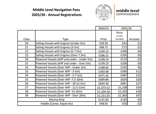
Our Navigation Advisory Committee has supported a 3.2% inflationary increase in our annual vessel registration charges for 2025. We brought forward the decision by a month to enable boaters and the three marinas on our system additional time to plan for the 2025 season. Forms and information available on our website will be updated in due course.

We have taken the decision to move away from mirroring the Environment Agency fee levels as we feel that we have sufficient experience now to form our own assessment. This does not change or threaten the Anglian Pass partnership.

We hope our loyal boaters appreciate our efforts to make incremental, modest and affordable improvements in our system? We recognise there is a way to go, particularly in terms of facilities and moorings. To get where we all want to be, we need additional registered vessels bringing in additional income alongside a resurgence of the volunteer and third sector endeavour that was so beneficial in past decades and that other navigations benefit from.

Whilst our ambition is to ensure an affordable and viable navigation experience for our valued boaters, we are facing major investment requirements ahead in terms of lock gate replacements and managing navigation depth. As this programme of investment becomes more mature, we will share and model what it may mean for fees over the medium term.

Visitor registration fees for 2025 will be determined early in the New Year.

Paul Burrows, Chief Executive

18th December 2024

In September 2023, we commenced a trial to test if and how manual intervention could result in more efficient and effective operation of St Germans pumping station. The trial will continue through the 2024/25 ‘pumping season’.

We are hoping the second winter of the trial will be closer to a ‘normal winter’ so we can broaden and deepen our learning. We will consider the results and learning from the trial in 2025 before making any decisions on any permanent changes to our operations. This briefing explains the background and context for a pumping operations trial.

Whether you’re a boater on our system, live alongside our navigable waterways or have an interest in the Middle Level navigation, we’d value your thoughts and feedback.

Please spend 10-15 minutes completing our survey. This will be open until 31st October 2024. Many thanks in advance.

The survey can be found via this link or the QR code below:


Anglian Water and Cambridge Water’s phase two consultation for the proposed reservoir in the Fens is now open and will run from 30th May 2024 until 23:59pm on 9th August 2024.

All phase two consultation materials can be accessed via the project website www.fensreservoir.co.uk as well as details of their community engagement events.

The proposed site is located in the heart of the Middle Level and the reservoir will need to integrate with our infrastructure and operations. Our system also opens up a blue and green web of biodiversity connectivity opportunities for the reservoir, as well as enabling navigation access to the reservoir from the national canal network.

Please review the consultation materials and provide your feedback.

Having successfully managed pumping operations through the wettest winter on record, our focus is now on our embankment and in-channel maintenance programme. The wet and relatively warm winter has meant we’ve had to adjust our plans.

In terms of in-channel management of aquatic weed, which is particularly important to those boating on our 160km of navigable waterways, this is what to expect in 2024:

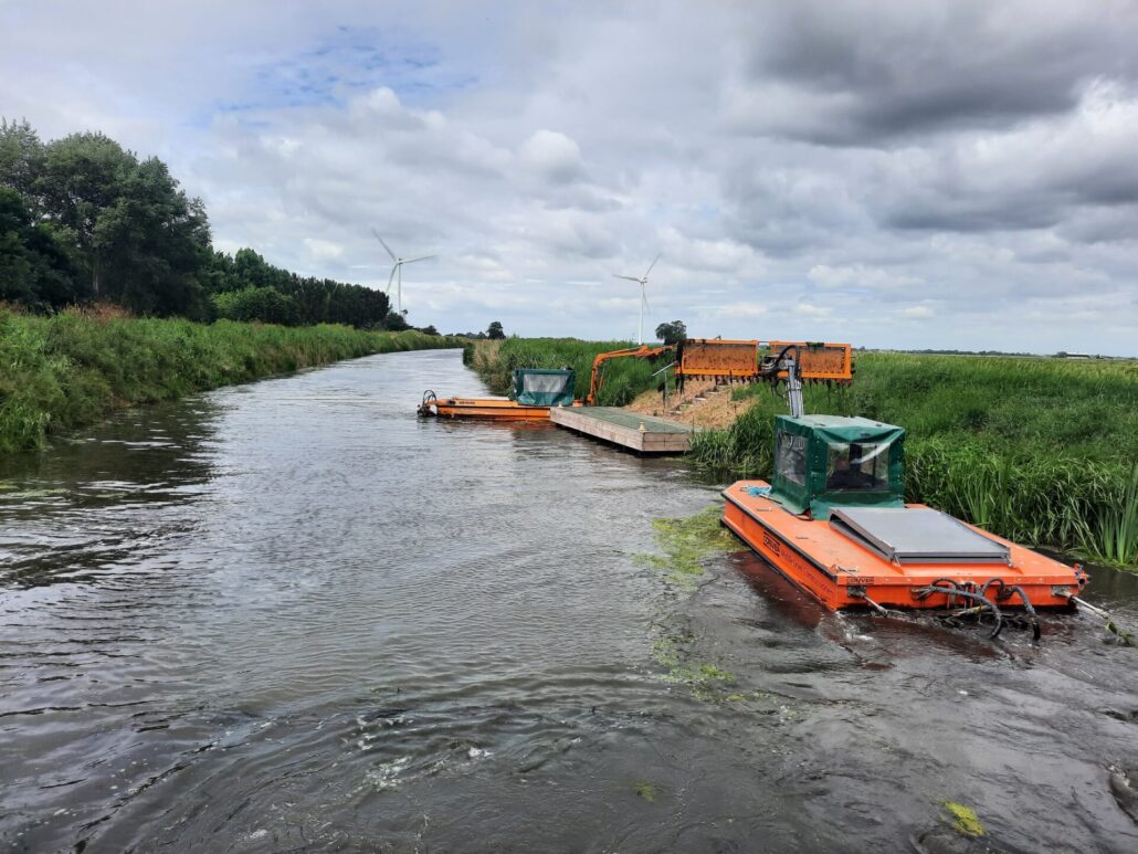
Our weed-boats are now in the water and ready for the season. We have five boats – two as weed cutters and three as weed lifters. Ideally, we form two crews, a crew of three boats generally focussed on the wider waterways and a crew of two boats focussed on the link route.

Our ability to have two crews active during a working week is dependent upon:

· Weather conditions

· Mechanical issues with the boats

· Boat crew availability and absence

To maximise what we can achieve, we are:

· Actively re-deploying members of our workforce to be part of our boat crews by using contractors for some other activities.

· Aiming to bring in, train and use additional boat operators this summer.

· Looking to maximise boat ‘cutting time’ rather than ‘travel time’. This will mean less responding to ‘hotspot’ weed-growth reports from boaters which has previously resulted in lost ‘cutting time’ and greater ‘travel time’.

· Improving our logistical and fuelling support to our boat crews.

We will endeavour to regularly post updates on our Facebook page as to where our crew(s) are within our system.

We’d love to be able to afford more boats and more operatives to manage weed growth to the standards many of those navigating our system would like. Sadly, that’s not our financial reality within boundaries of the income we receive from licence fees and from our ratepayers. Many boaters remember the days when weed growth within our system was significantly worse than it is today.

Please bear with us, as at a maximum we can only be in one or two places at a time within our 160km of navigable waterways.

As these crews will blend experienced hands with novice hands, we aim to get a crew out cutting on the wider waterways starting wc 20th May where there is less traffic. This is so they can test and perfect their teamwork before working within the narrower, busier channels.

If you see our crews in action, please wave and say hello.

The Middle Level Commissioners are responsible for the regulation on the Middle Level navigable waterways as outlined in Schedule One of the Middle Level Act (2018). This includes within marinas connected to our navigable waterways.

Regulation and enforcement are a necessary part of our role as a navigation authority and this includes for the power to remove vessels from our waterways which are unregistered, sunk, stranded, abandoned or left/moored without lawful authority.

We see removal as a last resort when dealing with unregistered vessels. Whenever possible we will work with the owners of vessels to bring them into compliance, ensuring they meet the requirements for registration which, to help ensure the safety of all who use the waterways, includes boat safety certification and insurance.

Registration income is essential for the maintenance and improvements of the navigation services we provide on our waterways. Not paying a licence fee or defaulting on payments directly affects the service we are able to provide, impacting fellow vessel owners.

The cost of removing vessels is considerable and in our experience so far rarely recoverable from absent and/or unknown owners. This is a financial burden within our navigation account that reduces our ability to deliver other navigation services and improvements.

The first version of our boat removal protocol was published on 16th October 2020 and the second version is an update based on experience and learning.

The updated protocol is available here. We would value any comments and feedback on the updated protocol before we finalise it. Please provide feedback within an email titled ‘MLC Boat removal protocol version 2; Feedback’ to admin@middlelevel.gov.uk by 24th May 2024.